Unmanned Aerial Systems to Monitor Mine Reclamation Success in Central Utah
This collaboration between Utah State University and the Utah Division of Oil, Gas and Mining (DOGM) will develop an effective landscape monitoring protocol to assist land managers in the evaluation of reclamation activities across the state.
Our test site is the Wilberg-Cottonwood coal mine located near Castle Dale, Utah, which has recently undergone reclamation activities to return the mine site to natural conditions.
The partnership between USU, DOGM, and the mine operator, PacifiCorp, which is responsible for the land reclamation work, has yielded a number of important data layers derived from airborne and ground-based platforms that we have been using to develop the monitoring protocol.
These data sets include:
- 2017-09-15 – PacifiCorp/Aerographics Inc. - Fixed-wing UAS, aerial Lidar
- 2018-01-18 – PacifiCorp/Aerographics Inc. - Fixed-wing UAS
- 2018-03-20 – PacifiCorp/Aerographics Inc. - Fixed-wing UAS
- 2018-05-17 – PacifiCorp/Aerographics Inc. - Fixed-wing UAS
- 2018-05-23 – OGM - Terrestrial Lidar
- 2019-05-03 – USU/OGM – Multi Rotor UAS – imagery/photogrammetric point cloud
- 2019-05-24 – USU/OGM - Multi Rotor UAS – imagery/photogrammetric point cloud
- 2019-06-05 – USU/OGM - Multi Rotor UAS – imagery/photogrammetric point cloud
- 2019-06-20 – OGM – Multi Rotor UAS – Micasense color infrared imagery/photogrammetric point cloud
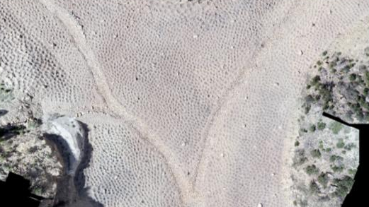
The collection of ultra-high ground resolution (~2.5cm) imagery and topographic data will allow us to monitor the changes in the landscape which has been “pocked” to produce thousands of micro-watersheds. These “pocks” (Figure 1) are intended to slow the downhill movement of water, thus curbing erosion and trapping water locally for plant growth. Over time, seeded vegetation will grow and these pocks will fill with sediment leaving the landscape in a semi-natural condition. Our purpose is to monitor and measure the amount of sedimentation inside each pock.
Graduate Assistant Christopher Brown, has been busy organizing, standardizing, and analyzing data. Using these data, he has been successful in identifying each individual pock (Figure 2) so that we can identify spatial patterns of infilling and vegetation growth. There are approximately 13,500 pocks in the reclaimed area.
These data will allow OGM to monitor the entire landscape with a level of detail that has not been available to land managers in the past.
Imagery collected by UAS’s will provide a unique ability to systematically and simultaneously monitor minute changes in topography, thus catching erosional events quicker, and to monitor vegetation growth (Figures 3 & 4).
The monitoring protocols developed in this study will be used by OGM as a template to monitor other reclamation sites.
Professor R. Douglas Ramsey, director of the USU Remote Sensing/Geographic Information Systems Lab, Doug.Ramsey@usu.edu, Graduate Assistant Christopher Brown, and Christopher McGinty, associate director, USU Remote Sensing/GIS Lab.
DOGM collaborators: GIS specialist Thomas Thompson, soil scientist Priscilla Burton.